Blog |
Floods in Senegal, are retention basins part of the solution?
In Dakar, Senegal, floods are major disruptions. Pape Goumba Lo, Geologist discusses solutions.
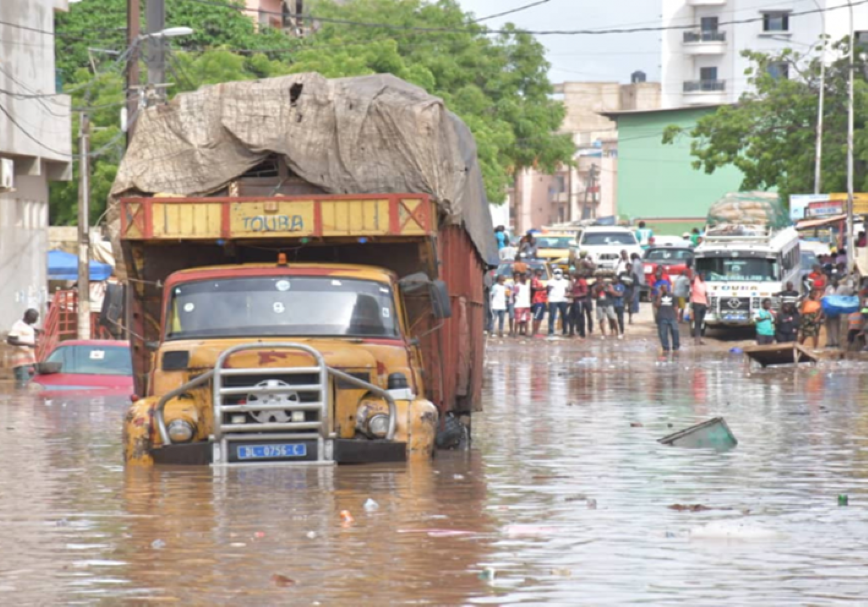
The disruption of the social environment due to flooding is a major concern in the Senegalese capital. The population increase in the cities, the unplanned urban constructions and the concentration of at least 70% of the activities in the region are the causes. What should be done then? How to combine development and non-development? How can we prevent rainwater from destroying already inhabited areas? This article offers some tentative answers taken from the Coastal Radio program on flooding in Senegal
For more than twenty years, Senegal has been facing floods every rainy season between the end of May and September. The populations suffer the martyrdom while the governmental strategies to overcome this plague struggle to give results. To analyze the situation and propose solutions, the radio program La Voix du Littoral invited Pape Goumba Lô, professor at the University of Dakar, geologist and environmentalist. The discussion focused on Dakar, a peninsula suffering from an urban push beyond its limits, since even the basins are home to shacks and permanent buildings. And during the program, two words were redundant: relocation and development.
The approach will consist first of all in seeing the causes of the floods, to be faithful to the initial question of the host of the program, the journalist Marième Mbengue. Mr. Pape Goumba Lô will explain scientifically that we have developed and urbanized without knowing the floodable and non-habitable areas. In Dakar and its overpopulated suburbs, there are low areas in terms of basins such as Liberté VI, Castors, Maristes, Dalifort, Pikine, Diamniadio, and high areas such as Cap Manuel.
Evoking the history, Mr. Lô teaches listeners that tens of thousands of years ago, there were natural waterways, before the culture of sedentarization, with the construction of houses and consequently, any development work in Dakar had to take into account this reality. But by not wanting to comply with this requirement, the storage area called catchment area, occupied today anarchically as well as Les Maristes, identified as a place of flow, are among the causes of the floods of the moment because they no longer play their natural roles. Given the situation, the simplest principle is to move if we do not develop. But is it possible, in spite of everything, to develop without moving? asked Mrs. Marième Mbengue. Yes, answers the engineer! Because in places like Thiaroye, the variation of the water table, which is not too deep, is respected. One of the solutions would be the construction of retention basins with a diameter of 1 to 2 ha, and a height of 4 or even 5. This is certainly possible, but it cannot justify this tendency to copy everything that is done elsewhere. The spirit of innovation must prevail among Senegalese engineers, advocates Mr. Lô.
"Where the Cité Fayçal in Cambérène was built, horse races were organized. I had asked that it be developed for future fishing activities," he said, since it was naturally suitable. Located in the Niayes area that runs from Dakar to Saint-Louis, a favorite place for horticultural crops, taking this request into account would certainly have helped to avoid the flooding cases recorded in recent years.
The bad planning policies combined with the urbanist push have created a catastrophic situation without forgetting the effects of climate change, will point out the host of the program. An argument with the value of a question to which the environmentalist will answer: "We will know more and more torrential rains. It will therefore be necessary to have a policy of prevention, and prevention is the set of organizational methods," he said.
In 2022, Dakar experienced an unprecedented situation with very heavy flooding in the Cité des Almadies, an upscale district of the capital: the Dakar airport was no longer able to play a stabilizing role, the basaltic soil of Mamelles composed of clay and the soil of the dunes of Cambérène, both of which had the capacity to absorb water and, as a result, to maintain the water table under the basalt, were developed and built. By allocating the land of the former main airport of the capital, this entire ecosystem was disrupted. Thus the water, instead of being absorbed, flows into the sea which, in turn, floods the houses, will clearly explain Mr. Lô.
Moreover, in Sébikotane, at the exit of Dakar, on the road to Thiès, the water table, which allowed the cultivation of fruit, is in the process of being lowered since the development of the ZAC of Mbao.
What could be the consequences of these floods on the population in the long term? While acknowledging that he is not a health specialist, Pape Goumba Lô says he knows that water-borne diseases will be among them, because of the mixing of garbage with water; a fear that has led the hygiene service to mobilize a lot of financial funds for a good health prevention policy. But how to act to avoid the danger of contamination? To the question of Marième Mbengue, Mr. Lô will put forward in his answer the technical possibility of storing water. According to him: "It is useless to pump the water to send it to another place and then to see it coming back to the starting point. It will have to be kept in storage basins that can hold millions of liters. With this in mind, it is important to build resistant walls, with an adequate height, as the WACA project plans to do. Hence the expression, redevelop without moving.
Most of the time, explains the environmentalist, the nature of the soil is not taken into account. In places where the soil is clay, the water runs off. Only, the areas that fulfilled the natural function of communication between the water tables of Thiaroye and Cambérène have been destroyed by the construction of houses. Similarly, he continues, in periods of rising sea, the Niayes, intermediate areas between the ocean and the continent, had the capacity to capture these waters. Without forgetting that the dams also have an impact on the coastline, notes Mr. Lô.
Given the complexity of the problem, the implementation of the WACA project in Senegal, "will take into account the sustainable development of coastal areas" and thus, will help fight against flooding, according to Pape Goumba Lô. Welcoming the regional nature of the program, he said: "We scientists do not see the borders. For example, the Barbary tongue located in Senegal, "goes all the way to Mauritania".